
Mikoa tajiri Tanzania 2023 GDP per Capita in Thousand Tsh, mikoa bora Tanzania, mikoa 10 mikubwa Tanzania, mikoa yenye mzunguko wa pesa Tanzania, The National Statistics Publication has been prepared by the National Bureau of Statistics (NBS). Tables have been compiled from statistics collected directly by NBS through Surveys and Censuses and also from secondary statistics compiled by respective Ministries, Departments and Agencies (MDAs). It is the third edition in the series of publications with (GDP) at 2015 constant prices which provides an overview of Mainland Tanzania economy.

It comprises the time series economic statistical information covering a seven to ten years period regarding main aggregates such as economic growth, disposable income, final consumption expenditures, imports and exports as well as regional GDP estimates at current and constant prices.
Mikoa tajiri Tanzania 2023 GDP per Capital in Thousand Tsh.
The following are Top 10 regions contributed to GDP more than other regions (Regions with the Largest Shares of GDP 2019), Figures in Million TZS.
Mikoa Tajiri GDP per Capita in Thousand Tsh.
1. DAR ES SALAAM
This is a city of Laxury, there are more traders due to the Port of Dar, it is a region made from the coastal region and its people are not very generous, and the income of one person is 4,678,751 per year.

The city of Dar es Salaam began as a small fishing village known as Mzizima. This village was founded by the Balawa who mixed with the Zaramo towards the areas of the East African Continent and which were known as ‘Caravan Routes’. The construction of the Sultan’s Residence along with the port officially started in 1865 in the area of Mzizima village. The construction was completed in 1866 and Sultan Majid bin Said moved to Dar es Salaam that year.
2. IRINGA
It is a region of the highlands in the south which is also famous for being very cold, most of the residents of this region are from the Wahehe tribe and they really like to eat meat and the income of each person is 4,028,544 per year.
Iringa region is situated in Southern highland of Tanzania between latitude 6.540 and 100 and longitude 33 and 370– 000 East. The region covers an area of 58,936 sq. km. Iringa is a charming town which lies at the heart of Tanzania’s tea industry. Set on the slopes of a cliff above the Little Ruaha River, this is the main centre for travel to the Ruaha National Park.
A mix of faded Bavarian and vibrant African architecture distinguish Iringa from most Tanzanian towns, and the place has a rich history. It was near here that in 1894, Hehe Chief Mkwawa built a 13km long and four meter high stockade in an attempt to fight off the advance of German colonization.
3. MBEYA
It is a region located in the highlands in the south which is very agricultural, it is a region with religious people especially the Nyakyusa and the income of each person is 3,788,604 per year.
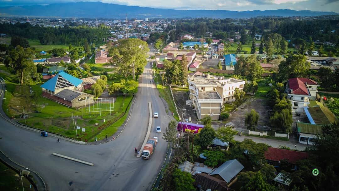
Mbeya Region is one of the four (4) regions in the Southern Highlands of Tanzania. Other regions are Rukwa, Iringa and Ruvuma. Mbeya region was established in 1961 and was known as ‘Southern Highland Province’ by including some areas of Iringa and Rukwa regions. The region has an area of km. of 63,617 square meters of which approx. of 61,783 square meters are land and km. of 1,834 square meters is the water area.
4. RUVUMA
It is a region named after the Ruvuma river, it is a region with six districts and has 63,498 square meters. The income of one person in this region is 3,396,587 per year.

Ruvuma Region is situated in the Southern part of Tanzania. It is located between latitude 90 35 and 110 south of the equator, longitudinal 340 31 and 38o 10 East Greenwhich. It shares borders with the Republic of Mozambique in the South, Lake Nyasa in the West and Iringa Region in the North and North East. It is also bordered by Mtwara Region to the East.
5. KILIMANJARO
It is a region famous for being home to Mount Kilimanjaro, whose income per person per year is 3,393,587. It is a region with seven districts and it is a developed region and its people are very generous.

The Kilimanjaro Region was officially established in 1963 by Government Announcement No. 450 of that year with Kilimanjaro and Pare districts.
Before Independence Kilimanjaro Region was part of the Northern Province (Northern Province) which was made up of Arusha and Mbulu districts, while Pare district was part of Tanga Province (Tanga Province).
- Dar es Salaam – 4,678,751
- Iringa – 4,028,544
- Mbeya – 3,788,604
- Ruvuma – 3,396, 587
- Kilimanjaro – 3,393,587
Source of the data is National Bureau of Statistics (NBC)
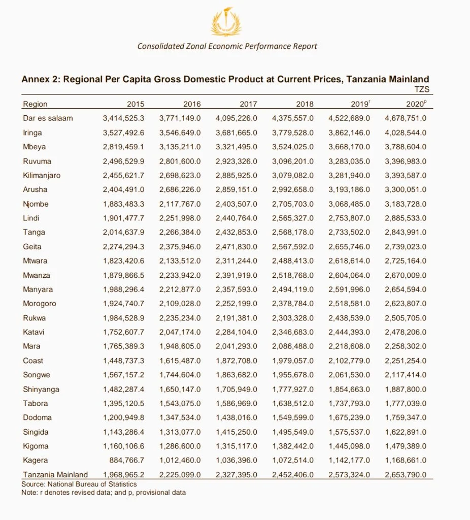
The main sources of data used in the compilation of the National Accounts Statistics for Mainland Tanzania include 2011/12 Household Budget Survey (HBS); 2014 Integrated Labour Force Survey (ILFS); 2007/08 Agriculture Sample Census; 2014/15 Annual Agriculture Sample Survey; 2013 Census of Industrial Production and 2015 Annual Surveys for Industrial Production.
Secondary information was extracted from administrative records which include information on imports and exports of goods and services, Government Finance Statistics (GFS) and Value Added Tax (VAT) collections. However, data from specific studies such as 2015 Trade and Transport Margins and Non-Profit Institutions Servings Households were also used.






kikweli sjui kwann kagera niyamisho hata kigoma kweli inatuzidi??